Showing posts with label landscapes. Show all posts

Scenes from Grand Teton National Park, Wyoming

Mount Moran, Grand Teton National Park, Wyoming
Snake River, looking toward Mount Moran, in Grand Teton National Park, Wyoming
Here are a couple of snapshots from the area around Jackson Hole, Wyoming.  The first, taken from the banks of the Snake River, shows Mount Moran, elevation 12, 605 feet (3,842 meters).  The mountain is located in Grand Teton National Park.

The second photo, below,  shows Jenny Lake, situated at the base of Grand Teton National Park's Cascade Canyon.  There is a nice seven-mile hiking trail around the perimeter of the lake.

Jenny Lake in Grand Teton National Park, Wyoming

Banks Peninsula, South Island, New Zealand

New Zealand sheep farm
Among the things New Zealand is known for are sheep farms, rugged coastlines and spectacular scenery. This photo encompasses all three of those features.  I happened on this scene while driving on a mountain road en route from Christchurch to the town of Akaroa on the Banks Peninsula of New Zealand's South Island.  When I stopped on the roadside to take this photo, I had to wonder if the sheep appreciated this wonderful view.

Orange Spring Mound at Yellowstone's Mammoth Hot Springs

Orange Spring Mound, Yellowstone National Park
Orange Spring Mound,  Mammoth Hot Springs, Yellowstone National Park, Wyoming
This photo shows the Orange Spring Mound, one of many curious features in the Mammoth Hot Springs area of Yellowstone National Park in Wyoming.

The National Park Service tells us:
Bacteria and algae create the streaks of color on Orange Spring Mound. It is noticeably different from many of the other terrace formations nearby. Its large mounded shape is the result of very slow water flow and mineral deposition.
You can learn more about Yellowstone's Mammoth Hot Springs and see photos of many of the geologic formations there by visiting the Mammoth Hot Springs Terraces Tour.

Clouds Forming Over the Badlands

Badlands National Park, South Dakota
Badlands National Park in southwestern South Dakota is one of those places that defies description.  The park itself covers more than 240,000 acres, much of which is characterized by erosion-carved buttes, pinnacles and other geologic formations.  The vastness of these features cannot be adequately captured in a photograph, and the wide open sky above adds to the feeling of limitless space.

Scattered along the roadsides through the park are overlook points that afford the visitor breathtaking views.  They also are excellent spots for weather-watching, offering unobstructed views across the surrounding prairies that seem to go on forever.

On the morning this photo was taken the sky was as clear a blue as can be imagined.  By midday this picture-perfect fleet of clouds had accumulated and the first of several passing rain squalls appeared over the buttes.

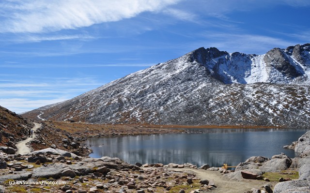
Summit Lake, Mount Evans, Colorado


Summit Lake, elevation 12,830 feet 
Location:  Mount Evans, Colorado, USA 

Mount Evans is one of 55 "Fourteeners" in Colorado - i.e. mountain peaks with summits higher than 14,000 feet above sea level.  The summit of Mount Evans is at an elevation of 14,265 feet (4,348 meters).  This small but picturesque alpine lake is situated somewhat below the actual summit of Mount Evans, but at an elevation of 12,830 feet, a hike along the trail that skirts the shore of the lake still can leave you a bit breathless!

Here is a different view of Summit Lake, posted last month.

Rabbit Ears Peak - A Colorado Landmark


Rabbit Ears Peak
Location:  Routt National Forest, Colorado, USA

The two stone pillars on top of this mountain peak are said to have served as a landmark for travelers across the Rocky Mountains since pioneer times.  When the feature was named initially, the two pillars were taller and looked more like real rabbit ears, but over time they have eroded.  The peak, which is part of the Park Range of the Rockies, is situated within the Routt National Forest.  The area is popular with hikers.

This photo was taken from Rabbit Ears Pass, which is located on a stretch of  U.S. Highway 40 between the Colorado towns of Kremmling and Steamboat Springs.  The Pass is at en elevation of 9,426 feet (2,873 meters).

Reflections at the edge of Summit Lake, Mount Evans, Colorado


Summit Lake, elevation 12,830 feet
Location:  Mount Evans, Colorado, USA

Summit Lake is an alpine lake situated above the tree line on Colorado's Mount Evans at an elevation of 12,830 feet above sea level.  It is surrounded by steep cliffs and rocky hills covered by tundra.  This lake is about 2,000 feet below the actual summit of Mount Evans, which rises to an elevation of 14,265 feet (4,348 meters).

Early Autumn Colors in Summit County, Colorado


Trees in Early Autumn
Location:  Summit County, Colorado, USA

It is still September, but many of the trees in the Colorado high country already are sporting their Autumn colors.  Most of the trees on this hillside are aspens, famous for bright gold foliage at this time of year.  The photo was taken outside the little town of Blue River, Colorado.

Principal Peaks of the Teton Range


The Teton Range
Location:  Jackson Hole, Wyoming, USA

The peaks that form the Teton Range of the Rocky Mountains are located in western Wyoming.  This photo of the central massif was shot facing west from a spot in the Jackson Hole valley known as Windy Point. The peaks in this image, from left to right, are:

  • South Teton -- summit elevation 12, 514 ft   (3,814 m)
  • Middle Teton -- summit elevation 12,804 ft  (3,903 m)
  • Grand Teton -- summit elevation 13,770 ft  (4,200 m)
  • Mount Owen -- summit elevation 12,928 ft  (3,940 m)
  • Teewinot Mountain -- summit elevation  12,325 ft (3,757 m)
The Teton range is situated within the borders of Grand Teton National Park.

Forest Canyon Overlook, Rocky Mountain National Park


Forest Canyon Overlook
Location:  Rocky Mountain National Park, Colorado, USA

Trail Ridge Road, the main east-west thoroughfare through Colorado's Rocky Mountain National Park, climbs high into the mountains and crosses the Continental Divide.  Along the way, there are a number of overlooks where you can stop to enjoy spectacular views.  One of those is the Forest Canyon Overlook, pictured here.  Located above the tree line in an area dominated by tundra, this high perch affords the visitor unobstructed views in every direction.  The sights include huge mountains, several alpine lakes, and a dramatic gorge formed by ancient glaciers.

From the Rocky Mountain National Park website:
Like other high mountain valleys, Forest Canyon was filled with ice and shaped by glaciers during the past two million years.  Here, ice flowed through a stream valley and followed the straight line of the ancient faults.  Side valleys contributed their own rivers of ice, and carved the canyons of Hayden Gorge and Gorge Lakes.  The Rolling terrain of the high country was untouched by glacial ice.

Scenic Endovalley, Rocky Mountain National Park


The meadow at Endovalley
Location:  Rocky Mountain National Park, Colorado, USA

This is a view of an area of Rocky Mountain National Park known as Endovalley.   Large animals like elk and Bighorn sheep are often seen grazing in this meadow.  The photo was taken near the base of the Old Fall River Road.  At the back of the valley, that's Sundance Mountain (summit elevation 12,466 ft) on the left, and Mount Chapin (summit elevation 12,454 ft) on the right.  Endovalley is popular with hikers and rock climbers.

Field of Russell Lupines in New Zealand's Fiordland


Russell Lupines (Lupinus polyphyllus)
Location: Fiordland, South Island, New Zealand

Recently I unearthed this image from a 2007 journey to New Zealand.  It was springtime there (December) and the countryside was richly blanketed with wildflowers.  Among our favorites were these Russell Lupines.

Here is a close-up photo of Russell Lupines from that same trip to New Zealand.

Rocky Mountain High: The Long's Peak Massif


Mount Meeker, Long's Peak and Mount Lady Washington
Location: Colorado, USA

These are the three most prominent peaks in the Long's Peak Massif.  From left to right, Mount Meeker, elevation 13,911 feet (4,240 meters); Long's Peak, elevation 14,255 feet (4,345 meters); and Mount Lady Washington 13,281 feet (4,048meters).  These mountains form a part of Colorado's Front Range.

This view of the Long's Peak Massif was photographed from an overlook on Colorado Highway 7, just north of Meeker Park.  That stretch of of Route 7 is a part of the Peak to Peak Scenic Byway, a system of roads traversing the foothills of the Front Range from Estes Park in the north, to Interstate 70 in the south.

Field of golden wildflowers in Colorado


Location: Grand County, Colorado, USA

Last time, I posted a close-up photo of an American wildflower called Golden Smoke (Corydalis aurea), which I photographed in a rural Colorado meadow.  Here is that meadow.

Sprague Lake in Rocky Mountain National Park


Sprague Lake
Location: Rocky Mountain National Park, Colorado, USA

This lake is situated near the eastern edge of Rocky Mountain National Park in Colorado.  Sprague Lake lies at an elevation of more than 8,000 feet.  It once was a part of a privately owned resort, prior to the establishment of the national park.  Today there is a picnic area near where the resort's lodge used to be.  There is a well-maintained walking trail around the perimeter of the lake.  This photo, a view facing west across the lake, was taken from that trail.

The mountains in the background of this photo form a part of the Continental Divide.  The pointy-topped mountain in the far left of the photo is Taylor Peak, elevation 13,158 feet.  To its right is Otis Peak, elevation  12,486 feet.  Next is Hallett Peak, elevation  12,713 feet.  To the right of that is Flattop Mountain, elevation  12,324 feet.  Finally, in the far right of the photo, is Notchtop Mountain, elevation 12,129 feet.

Maggie Pond, Breckenridge, Colorado


Maggie Pond
Location: Breckenridge, Colorado, USA

This is Maggie Pond, in Breckenridge, a resort town situated more than 9,000 feet above sea level in Summit County, Colorado.  Ice-skaters frequent Maggie pond during the winter.  In summer, it is the scene of boat rides.  Regardless of the season, you can't fault the surrounding scenery!

June Snow in Rocky Mountain National Park, Colorado


Trail Ridge Road, AKA US Route 34
Location:  Rocky Mountain National Park, Colorado, USA

This is Trail Ridge Road, the main road through Rocky Mountain National Park in Colorado.  According to the National Park Service, "Rocky Mountain National Park has the highest paved roads in any National Park in the United States. Trail Ridge Road crests at 12,183 feet.  Due to the high elevations and exposure park roads are subject to strong winds and rapid weather changes."

The photo was taken on June 7, 2011 -- one day after this road was opened for the 2011 season.  As you can see, the snow alongside the road was still several meters high.


Kayaking on the Snake River in Grand Teton National Park


Kayaking on the Snake River at Oxbow Bend
Location:  Grand Teton National Park, Wyoming, USA

This past September my husband and I vacationed in Wyoming, where we visited both Grand Teton National Park and Yellowstone National Park.  Both were dream destinations for a nature photographer.  This is the first of many photos I will post from that trip.

P.S.  I wrote a short article about that trip as an invited guest post for the "Remembering 2010 Travels" series on the Harrisburg International Airport blog:  Wyoming’s Grand Teton & Yellowstone National Parks: Wild America

Taiaroa Head on New Zealand's Otago Peninsula


Taiaroa Head
Location:  Otago Peninsula, South Island, New Zealand

The Otago Peninsula juts eastward from the city of Dunedin on New Zealand's South Island.  The cape at the tip of the Peninsula is known as Taiaroa Head.  The lighthouse there was first built in the mid-nineteenth century.  It's a very picturesque spot, don't you think?

Taiaroa Head is a nature preserve.  A large number of seabirds nest in the area.  Notably, it is home to a breeding colony of Royal Albatross (Diomedea sanfordi), the world's largest seabird species. In fact, the Royal Albatross colony at Taiaroa Head is said to be the only mainland breeding colony for any albatross species found in the southern hemisphere.

The waters around Taiaroa Head are home to several species of marine mammals such as seals, sea lions, dolphins, and migratory whales.  A few years ago I wrote a piece on my ocean blog, The Right Blue, about an encounter with New Zealand Fur Seals (Arctocephalus forsteri) at Taiaroa Head (with photos). Here's the link to that post about male fur seals at Taiaroa Head.

Timeless Puako, Hawaii

Puako,Hawaii

Puako shoreline
Location: Kohala Coast, Big Island, Hawaii

Puako is a small seaside village on the Kohala Coast of Hawaii's Big Island.  The rugged coastline at Puako was created by an old lava flow from Mauna Loa volcano.  The dark sections jutting into the ocean in this photo are fingers of that old lava flow.  The coastline here is very irregular, featuring stretches of black lava punctuated by small pocket beaches composed of coral sand.  There are a few small black sand beaches there as well.  Because the surface of the lava along the shore is so uneven, there are plenty of tidepools.

We lived in Puako for awhile in the 1990s, until we moved to a new house several miles up the coast.  Although we no longer live there, Puako is still our favorite spot for diving, snorkeling and tidepooling.